| dbo:PopulatedPlace/areaTotal
|
- 1564.352818642944 (dbd:squareKilometre)
|
| dbo:areaLand
|
- 1538452937.539584 (xsd:double)
|
| dbo:areaTotal
|
- 1564352818.642944 (xsd:double)
|
| dbo:areaWater
|
- 25899881.103360 (xsd:double)
|
| dbo:country
| |
| dbo:countySeat
| |
| dbo:description
|
- comitat din Statele Unite ale Americii (ro)
- contea statunitense (it)
- κομητεία στην πολιτεία Αλαμπάμα των ΗΠΑ (el)
- ოლქი აშშ-ში, ალაბამის ოლქი (ka)
- ABD'nin Alabama eyaletine bağlı ilçe (county) (tr)
- Comtat a Alabama, Estats Units (ca)
- County im US-Bundesstaat Alabama (de)
- Jungtinių Amerikos Valstijų ir Alabamos apygarda (lt)
- comté de l'Alabama, aux USA (fr)
- condado en Alabama, Estados Unidos (es)
- condáu d'Alabama (Estaos Xuníos) (ast)
- county i Alabama, USA (sv)
- county in Alabama, United States (en)
- hrabstwo w stanie Alabama w USA (pl)
- kantono en Alabamo, Usono (eo)
- okres v americkém státě Alabama (cs)
- qark në Alabama (sq)
- sir yn nhalaith Alabama, Unol Daleithiau America (cy)
- округ в штате Алабама, США (ru)
- округ у штаті Алабама, США (uk)
- מחוז באלבמה, ארצות הברית (iw)
- مقاطعة في ألاباما (ar)
- アラバマ州の郡 (ja)
- Alabama megyéje (hu)
- Contae in Alabama (ga)
|
| dbo:foundingYear
| |
| dbo:largestCity
| |
| dbo:percentageOfAreaWater
| |
| dbo:state
| |
| dbo:thumbnail
| |
| dbo:wikiPageExternalLink
| |
| dbo:wikiPageWikiLink
|
- dbr:Washington,_Alabama
- dbr:2020_United_States_census
- dbr:W._H._Lanier
- dbr:County_seat
- dbr:Mainline_Protestant
- dbr:Alcorn_State_University
- dbc:Populated_places_established_in_1818
- dbr:United_States_Census_Bureau
- dbr:Yazoo_City,_Mississippi
- dbr:Andrew_Jackson
- dbr:U.S._state
- dbc:Alabama_placenames_of_Native_American_origin
- dbr:Chilton_County,_Alabama
- dbr:Emancipation_Proclamation
- dbr:Dallas_County,_Alabama
- dbr:University_of_Alabama
- dbr:Elmore_County,_Alabama
- dbr:Southern_Baptist_Convention
- dbr:Unincorporated_area
- dbr:United_Methodist_Church
- dbr:Admission_to_the_Union
- dbr:Alabama
- dbr:United_States
- dbr:Marbury,_Alabama
- dbr:Booth,_Alabama
- dbr:In_the_Midnight_Hour
- dbr:Properties_on_the_Alabama_Register_of_..._Heritage_by_county_(Autauga–Choctaw)
- dbr:Rita_Williams-Garcia
- dbr:1976_United_States_presidential_election_in_Alabama
- dbr:Marriage
- dbr:Alabama_River
- dbr:Alabama_Territory
- dbr:Lowndes_County,_Alabama
- dbr:Montgomery_County,_Alabama
- dbr:Evergreen,_Autauga_County,_Alabama
- dbr:Daniel_Pratt_(industrialist)
- dbc:1818_establishments_in_Alabama_Territory
- dbr:Census
- dbr:Native_Americans_in_the_United_States
- dbr:Birmingham,_Alabama
- dbr:Confederate_States_of_America
- dbr:Millbrook,_Alabama
- dbr:Prattville,_Alabama
- dbr:Poverty_line
- dbr:Autauga_County_School_System
- dbr:Wilson_Pickett
- dbr:Per_capita_income
- dbc:Autauga_County,_Alabama
- dbr:Treaty_of_Fort_Jackson
- dbr:Autaugaville,_Alabama
- dbr:Billingsley,_Alabama
- dbr:Richardsonian_Romanesque
- dbr:Jones,_Alabama
- dbr:Autauga_County_Schools
- dbr:Cotton_gin
- dbr:Jimmy_Carter
- dbr:Population_density
- dbr:Bishop
- dbc:Montgomery_metropolitan_area
- dbr:County_(United_States)
- dbr:Jackson,_Mississippi
- dbr:Montgomery,_Alabama
- dbr:Gulf_Coastal_Plain
- dbr:Pine_Level,_Autauga_County,_Alabama
- dbr:Mustang_Sally_(song)
- dbr:Prattville_Dragoons
- dbr:Creek_War
- dbr:Central_Alabama
- dbr:Alabama_(people)
- dbr:Atlantic_Seaboard_Fall_Line
- dbr:African_American
- dbr:Reconstruction_era_of_the_United_States
- dbr:Montgomery_metropolitan_area
- dbr:White_(U.S._Census)
- dbr:U.S._Route_82_in_Alabama
- dbr:Clergyman
- dbr:Mulberry,_Autauga_County,_Alabama
- dbr:Alabama_State_Route_111
- dbr:National_Register_of_Historic_Places_listings_in_Autauga_County,_Alabama
- dbr:U.S._Route_31_in_Alabama
- dbr:East_Memorial_Christian_Academy
- dbr:Samuel_Smith_Harris
- dbr:Public_education
- dbr:Presbyterian
- dbr:United_States_Civil_War
- dbr:Kingston,_Alabama
- dbr:Evangelical_Protestant
- dbr:Pacific_Islander_(U.S._Census)
- dbr:Autauga_(tribe)
- dbr:Charles_Atwood_(Alabama)
- dbr:File:Alabama_111.svg
- dbr:File:Alabama_14.svg
- dbr:File:Alabama_143.svg
- dbr:File:I-65_(AL).svg
- dbr:Jackson's_Mill,_Alabama
- dbr:South_and_North_Railroad
- dbr:Tawasa_(tribe)
- dbr:African_American_(U.S._Census)
- dbr:File:US_82.svg
- dbr:Latino_(U.S._Census)
- dbr:State_Route_143_(Alabama)
- dbr:State_Route_14_(Alabama)
- dbr:Hispanic_(U.S._Census)
- dbr:Interstate_65_(Alabama)
- dbr:Race_(United_States_Census)
- dbr:Native_American_(U.S._Census)
- dbr:Asian_(U.S._Census)
- dbr:File:US_31.svg
|
| dbp:align
| |
| dbp:areaLandSqMi
| |
| dbp:areaPercentage
| |
| dbp:areaTotalSqMi
| |
| dbp:areaWaterSqMi
| |
| dbp:bot
| |
| dbp:caption
|
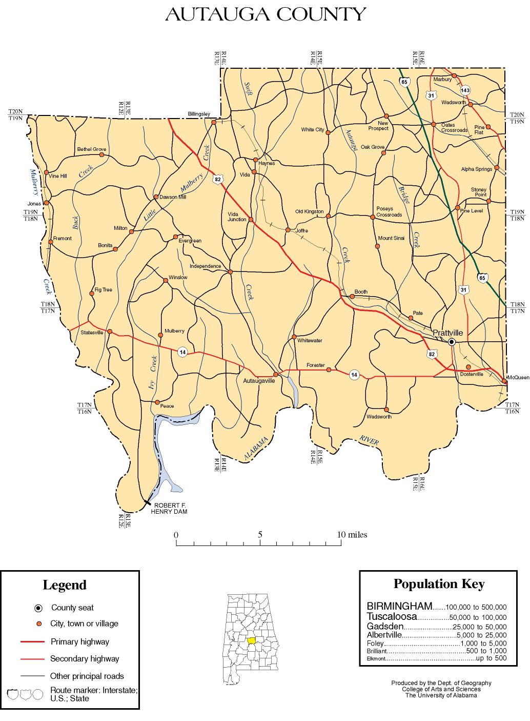
- Approximate divisions used in the 1930 census. Similar to those used from 1900 to 1940. (en)
- Current divisions as of the 2020 census, in use since at least 1990. (en)
- Approximate divisions used in the 1950 census. (en)
- Approximate divisions used in the 1850 and 1860 censuses. The white dotted line represents the current county boundary. (en)
|
| dbp:centre
|
- Autauga County, Alabama (en)
|
| dbp:county
| |
| dbp:date
| |
| dbp:direction
| |
| dbp:district
| |
| dbp:east
| |
| dbp:exImage
|
- Autauga County Courthouse March 2010 02.jpg (en)
|
| dbp:exImageCap
|
- Autauga County Courthouse in Prattville (en)
|
| dbp:fixAttempted
| |
| dbp:footnotes
|
- *County Number 04 on Alabama Licence Plates (en)
|
| dbp:foundedDate
|
- 0001-11-21 (xsd:gMonthDay)
|
| dbp:foundedYear
| |
| dbp:group
| |
| dbp:header
|
- Historical census county divisions of Autauga County (en)
|
| dbp:image
|
- Autauga_County,_Alabama_census_divisions,_1990-2020.tif (en)
- Autauga_County,_Alabama_census_divisions,_1930.tif (en)
- Autauga_County,_Alabama_census_divisions,_1950.tif (en)
- Autauga_County,_Alabama_census_divisions,_1850-1860.tif (en)
|
| dbp:largestCityWl
| |
| dbp:logo
|
- Logo of Autauga County, Alabama.png (en)
|
| dbp:name
|
- Note01 (en)
- Note02 (en)
- Note03 (en)
- Note04 (en)
- Note05 (en)
|
| dbp:north
| |
| dbp:place
|
- Autauga County, Alabama (en)
|
| dbp:popEstAsOf
| |
| dbp:populationAsOf
| |
| dbp:populationDensityKm
| |
| dbp:populationEst
| |
| dbp:populationTotal
| |
| dbp:seal
|
- Seal of Autauga County, Alabama.svg (en)
|
| dbp:seatWl
| |
| dbp:south
| |
| dbp:southeast
| |
| dbp:state
| |
| dbp:timeZone
| |
| dbp:totalWidth
| |
| dbp:web
| |
| dbp:west
| |
| dbp:width
| |
| dbp:wikiPageUsesTemplate
| |
| dbp:wordnet_type
| |
| dct:subject
| |
| gold:hypernym
| |
| schema:sameAs
| |
| georss:point
|
- 32.53666666666667 -86.64833333333333
|
| rdf:type
| |
| rdfs:label
|
- Autauga County, Alabama (en)
- مقاطعة أوتوغا (ألاباما) (ar)
- Comtat d'Autauga (ca)
- Autauga County (cs)
- Autauga konderria (Alabama) (eu)
- Condado de Autauga (es)
- Autauga County (de)
- Contae Autauga, Alabama (ga)
- County Autauga, Alabama (in)
- Comté d'Autauga (fr)
- オートーガ郡 (アラバマ州) (ja)
- Contea di Autauga (it)
- 오토가군 (ko)
- Autauga County (nl)
- Condado de Autauga (pt)
- Отога (округ) (ru)
- Hrabstwo Autauga (pl)
- Autauga County (sv)
- Отога (округ, Алабама) (uk)
- 奥陶加县 (zh)
|
| owl:sameAs
|
- yago-res:Autauga County, Alabama
- http://www.rdfabout.com/rdf/usgov/geo/us/al/counties/autauga_county
- http://gadm.geovocab.org/id/2_34789
- freebase:Autauga County, Alabama
- http://viaf.org/viaf/152454197
- geodata:Autauga County, Alabama
- wikidata:Autauga County, Alabama
- dbpedia-it:Autauga County, Alabama
- dbpedia-nl:Autauga County, Alabama
- dbpedia-de:Autauga County, Alabama
- dbpedia-fr:Autauga County, Alabama
- dbpedia-tr:Autauga County, Alabama
- dbpedia-zh:Autauga County, Alabama
- dbpedia-ja:Autauga County, Alabama
- dbpedia-pt:Autauga County, Alabama
- dbpedia-ro:Autauga County, Alabama
- dbpedia-es:Autauga County, Alabama
- dbpedia-hu:Autauga County, Alabama
- dbpedia-fa:Autauga County, Alabama
- dbpedia-ru:Autauga County, Alabama
- dbpedia-sv:Autauga County, Alabama
- dbpedia-vi:Autauga County, Alabama
- dbpedia-pl:Autauga County, Alabama
- dbpedia-ko:Autauga County, Alabama
- dbpedia-id:Autauga County, Alabama
- dbpedia-et:Autauga County, Alabama
- dbpedia-ca:Autauga County, Alabama
- dbpedia-ar:Autauga County, Alabama
- dbpedia-az:Autauga County, Alabama
- dbpedia-azb:Autauga County, Alabama
- dbpedia-bar:Autauga County, Alabama
- dbpedia-bg:Autauga County, Alabama
- http://bpy.dbpedia.org/resource/আউটোগা_কাউন্টি,_আলাবামা
- dbpedia-ceb:Autauga County, Alabama
- dbpedia-cs:Autauga County, Alabama
- dbpedia-cy:Autauga County, Alabama
- dbpedia-eu:Autauga County, Alabama
- dbpedia-fi:Autauga County, Alabama
- dbpedia-ga:Autauga County, Alabama
- dbpedia-hr:Autauga County, Alabama
- dbpedia-hy:Autauga County, Alabama
- dbpedia-la:Autauga County, Alabama
- dbpedia-mk:Autauga County, Alabama
- dbpedia-mr:Autauga County, Alabama
- dbpedia-ms:Autauga County, Alabama
- dbpedia-nds:Autauga County, Alabama
- dbpedia-no:Autauga County, Alabama
- dbpedia-sh:Autauga County, Alabama
- dbpedia-simple:Autauga County, Alabama
- dbpedia-sq:Autauga County, Alabama
- dbpedia-sr:Autauga County, Alabama
- dbpedia-tt:Autauga County, Alabama
- dbpedia-uk:Autauga County, Alabama
- dbpedia-ur:Autauga County, Alabama
- dbpedia-war:Autauga County, Alabama
- dbpedia-ce:Autauga County, Alabama
- dbpedia-global:Autauga County, Alabama
- dbr:Autauga County, Alabama
|
| geo:geometry
|
- POINT(-86.648330688477 32.536666870117)
|
| geo:lat
| |
| geo:long
| |
| prov:wasDerivedFrom
| |
| foaf:depiction
| |
| foaf:homepage
| |
| foaf:isPrimaryTopicOf
| |
| foaf:name
| |
| is dbo:birthPlace
of | |
| is dbo:district
of | |
| is dbo:location
of | |
| is dbo:subdivision
of |
- dbr:Washington,_Alabama
- dbr:Marbury,_Alabama
- dbr:Booth,_Alabama
- dbr:Evergreen,_Autauga_County,_Alabama
- dbr:Millbrook,_Alabama
- dbr:Prattville,_Alabama
- dbr:Autaugaville,_Alabama
- dbr:Billingsley,_Alabama
- dbr:Jones,_Alabama
- dbr:Pine_Level,_Autauga_County,_Alabama
- dbr:Mulberry,_Autauga_County,_Alabama
- dbr:Kingston,_Autauga_County,_Alabama
|
| is dbo:wikiPageRedirects
of | |
| is dbo:wikiPageWikiLink
of |
- dbr:List_of_counties_by_U.S._state_and_territory
- dbr:List_of_county_courthouses_in_Alabama
- dbr:List_of_ghost_towns_in_Alabama
- dbr:Washington,_Alabama
- dbr:List_of_power_stations_in_Alabama
- dbr:1920_United_States_presidential_election_in_Alabama
- dbr:1980_United_States_presidential_election_in_Alabama
- dbr:1988_United_States_presidential_election_in_Alabama
- dbr:W._H._Lanier
- dbr:March_2019_North_American_blizzard
- dbr:Lady_Bird_Johnson
- dbr:List_of_United_States_counties_by_per_capita_income
- dbr:Thomas_William_Sadler
- dbr:List_of_United_States_tornadoes_from_January_to_March_2011
- dbr:Stone_Plantation
- dbr:WBIH
- dbr:1948_United_States_presidential_election_in_Alabama
- dbr:Chilton_County,_Alabama
- dbr:Dallas_County,_Alabama
- dbr:Elmore_County,_Alabama
- dbr:Alabama_State_Route_14
- dbr:Alabama_State_Route_140
- dbr:Alabama_State_Route_206
- dbr:Interstate_65_in_Alabama
- dbr:February_2007_North_American_blizzard
- dbr:List_of_Alabama_state_forests
- dbr:List_of_covered_bridges_in_Alabama
- dbr:List_of_tornadoes_in_the_1999_Oklahoma_tornado_outbreak
- dbr:The_Rosenwald_School_Building_Fund_and...uildings_Multiple_Property_Submission
- dbr:U.S._Route_31
- dbr:Alabama
- dbr:Alabama_Senate
- dbr:Index_of_U.S._counties
- dbr:Effects_of_Hurricane_Dennis_in_Alabama
- dbr:Benjamin_Fitzpatrick
- dbr:Marbury,_Alabama
- dbr:Booth,_Alabama
- dbr:Hurricane_Cindy_(2005)
- dbr:Alabama's_2nd_congressional_district
- dbr:Alabama's_3rd_congressional_district
- dbr:Alabama_Champion_Tree_Program
- dbr:Alabama_Circuit_Courts
- dbr:Alabama_Department_of_Public_Health
- dbr:Alabama_Department_of_Youth_Services
- dbr:Alabama_Republican_Party
- dbr:Alabama_statistical_areas
- dbr:Albert_J._Pickett
- dbr:List_of_Alabama_locations_by_per_capita_income
- dbr:Great_Storm_of_1975
- dbr:Properties_on_the_Alabama_Register_of_..._Heritage_by_county_(Autauga–Choctaw)
- dbr:1976_United_States_presidential_election_in_Alabama
- dbr:1984_United_States_presidential_election_in_Alabama
- dbr:2012_United_States_presidential_election_in_Alabama
- dbr:List_of_municipalities_in_Alabama
- dbr:Lowndes_County,_Alabama
- dbr:Montgomery_County,_Alabama
- dbr:31st_Cavalry_Regiment_(United_States)
- dbr:Evergreen,_Autauga_County,_Alabama
- dbr:Edmund_Meredith_Shackelford
- dbr:Daniel_Holcombe_Thomas
- dbr:Daniel_Pratt_(industrialist)
- dbr:2016_United_States_presidential_election_in_Alabama
- dbr:Millbrook,_Alabama
- dbr:Prattville,_Alabama
- dbr:Wetumpka,_Alabama
- dbr:Plantersville,_Alabama
- dbr:Autauga
- dbr:Autauga_Co.,_AL
- dbr:Autauga_Co.,_Alabama
- dbr:Autauga_County,_AL
- dbr:Autauga_County,_Al
- dbr:Autauga_County_Sheriff's_Office_(Alabama)
- dbr:Autauga_County_Sheriff's_Office
- dbr:Alabama_House_of_Representatives
- dbr:List_of_hospitals_in_Alabama
- dbr:Tornado_outbreak_of_November_23–24,_2001
- dbr:List_of_United_States_tornadoes_from_January_to_February_2008
- dbr:Tornadoes_of_2004
- dbr:United_States_District_Court_for_the_Middle_District_of_Alabama
- dbr:Autaugaville,_Alabama
- dbr:Billingsley,_Alabama
- dbr:Cuba,_Alabama
- dbr:Deatsville,_Alabama
- dbr:Lowndesboro,_Alabama
- dbr:Martha_Roby
- dbr:Tornado_outbreak_of_March_2–3,_2012
- dbr:Jones,_Alabama
- dbr:April_1924_tornado_outbreak
- dbr:Tornado_outbreak_of_April_14–16,_2011
- dbr:Autauga_County_Schools
- dbr:List_of_Alabama_placenames_of_Native_American_origin
- dbr:List_of_museums_in_Alabama
- dbr:Montgomery–Janes–Whittaker_House
- dbr:Alabama_Highway_Patrol
- dbr:Mulberry_Creek_(Alabama_River_tributary)
- dbr:Lowndesboro_Historic_District
- dbr:Tornado_outbreak_of_December_16,_2000
- dbr:List_of_United_States_tornadoes_from_January_to_March_1982
- dbr:List_of_United_States_tornadoes_from_November_to_December_2010
- dbr:List_of_United_States_tornadoes_from_November_to_December_2011
- dbr:List_of_United_States_tornadoes_in_May_2009
- dbr:List_of_U.S._county_name_etymologies_(A–D)
- dbr:List_of_U.S._municipalities_in_multiple_counties
- dbr:1892_United_States_presidential_election_in_Alabama
- dbr:1896_United_States_presidential_election_in_Alabama
- dbr:1900_United_States_presidential_election_in_Alabama
- dbr:1904_United_States_presidential_election_in_Alabama
- dbr:1908_United_States_presidential_election_in_Alabama
- dbr:List_of_United_States_counties_and_county_equivalents
- dbr:Bethel_Grove
- dbr:Pine_Level,_Autauga_County,_Alabama
- dbr:List_of_places_in_Alabama:_A–C
- dbr:List_of_places_in_Alabama:_D–H
- dbr:List_of_places_in_Alabama:_I–M
- dbr:List_of_places_in_Alabama:_N–R
- dbr:List_of_places_in_Alabama:_S–Z
- dbr:List_of_plantations_in_Alabama
- dbr:List_of_tornadoes_in_the_tornado_outbreak_of_April_14–16,_2011
- dbr:Marcus_Henderson_Cruikshank
- dbr:Prattville_Dragoons
- dbr:Prattville–Grouby_Field
- dbr:58th_Alabama_Infantry_Regiment
- dbr:National_Register_of_Historic_Places_Multiple_Property_Submissions_in_Alabama
- dbr:List_of_census-designated_places_in_Alabama
- dbr:List_of_unincorporated_communities_in_Alabama
- dbr:2016_Alabama_Democratic_presidential_primary
- dbr:William_Wyatt_Bibb
- dbr:Tornado_outbreak_of_November_27–28,_2005
- dbr:List_of_United_States_tornadoes_in_March_1973
- dbr:List_of_U.S._state_senators
- dbr:1928_United_States_presidential_election_in_Alabama
- dbr:Montgomery_metropolitan_area
- dbr:R.E._"Bob"_Woodruff_Lake
- dbr:Mount_Sinai_School
- dbr:2017_United_States_Senate_special_election_in_Alabama
- dbr:Edwina_Donnelly_Mitchell
- dbr:2020_Alabama_Democratic_presidential_primary
- dbr:1835_Alabama_gubernatorial_election
- dbr:7th_Alabama_Infantry_Regiment
- dbr:Tornado_outbreak_of_March_16–18,_2021
- dbr:Outline_of_Alabama
- dbr:1964_United_States_presidential_election_in_Alabama
- dbr:1992_United_States_presidential_election_in_Alabama
- dbr:1996_United_States_presidential_election_in_Alabama
- dbr:2000_United_States_presidential_election_in_Alabama
- dbr:2004_United_States_presidential_election_in_Alabama
- dbr:2008_United_States_presidential_election_in_Alabama
- dbr:Vehicle_registration_plates_of_Alabama
- dbr:List_of_Rosenwald_schools
- dbr:1956_United_States_presidential_election_in_Alabama
- dbr:1912_United_States_presidential_election_in_Alabama
- dbr:List_of_United_States_tornadoes_from_January_to_March_2019
- dbr:Tornado_outbreak_of_March_3,_2019
- dbr:USS_Autauga
- dbr:Samuel_Farrow_Rice
- dbr:List_of_United_States_tornadoes_from_August_to_October_2017
- dbr:U.S._Route_82_in_Alabama
- dbr:Wendell_Mitchell
- dbr:2020_United_States_Senate_election_in_Alabama
- dbr:1859_Alabama_gubernatorial_election
- dbr:January_2019_North_American_winter_storm
- dbr:Mulberry,_Autauga_County,_Alabama
- dbr:Tawasa_people
- dbr:Alabama_State_Route_111
- dbr:2020_Alabama_Republican_presidential_primary
- dbr:1819_Alabama_gubernatorial_election
- dbr:1821_Alabama_gubernatorial_election
- dbr:1823_Alabama_gubernatorial_election
- dbr:1831_Alabama_gubernatorial_election
- dbr:John_Mitchell_(outfielder)
- dbr:National_Register_of_Historic_Places_listings_in_Autauga_County,_Alabama
- dbr:U.S._Route_31_in_Alabama
- dbr:East_Memorial_Christian_Academy
- dbr:1972_United_States_presidential_election_in_Alabama
- dbr:Samuel_Smith_Harris
- dbr:Kingston,_Autauga_County,_Alabama
- dbr:2020_United_States_presidential_election_in_Alabama
- dbr:List_of_United_States_tornadoes_from_November_to_December_2018
- dbr:1932_United_States_presidential_election_in_Alabama
- dbr:Tornado_outbreak_of_November_30_–_December_2,_2018
- dbr:Interstate_construction_during_the_Civil_Rights_Movement_in_Montgomery,_Alabama
- dbr:1940_United_States_presidential_election_in_Alabama
- dbr:1944_United_States_presidential_election_in_Alabama
- dbr:Autauga_Academy
- dbr:List_of_United_States_tornadoes_from_January_to_March_2018
- dbr:MAX_Credit_Union
- dbr:2022_Alabama_gubernatorial_election
- dbr:3rd_Alabama_Infantry_Regiment
- dbr:Henry_F._DeBardeleben
- dbr:Same-sex_marriage_in_Alabama
- dbr:1888_United_States_presidential_election_in_Alabama
- dbr:1952_United_States_presidential_election_in_Alabama
- dbr:1936_United_States_presidential_election_in_Alabama
- dbr:1968_United_States_presidential_election_in_Alabama
- dbr:List_of_United_States_tornado_emergencies
- dbr:Tornado_outbreak_of_May_2–4,_2021
- dbr:2022_Alabama_Secretary_of_State_election
- dbr:List_of_district_attorneys_by_county
- dbr:List_of_stroke_centers_in_the_United_States
- dbr:Cost_of_rent_by_state_and_county_in_the_United_States
- dbr:List_of_United_States_FIPS_codes_by_county
- dbr:Dixon_Hall_Lewis
- dbr:2008_Tropical_Storm_Fay_tornado_outbreak
- dbr:Autauga_County
- dbr:Tornado_outbreak_of_November_2004
- dbr:History_of_Autauga_County,_Alabama
|
| is dbp:birthPlace
of | |
| is dbp:counties
of | |
| is dbp:county
of | |
| is dbp:deathPlace
of | |
| is dbp:district
of | |
| is dbp:north
of | |
| is dbp:northeast
of | |
| is dbp:northwest
of | |
| is dbp:shipNamesake
of | |
| is dbp:south
of | |
| is dbp:subdivisionName
of |
- dbr:Washington,_Alabama
- dbr:Marbury,_Alabama
- dbr:Booth,_Alabama
- dbr:Evergreen,_Autauga_County,_Alabama
- dbr:Millbrook,_Alabama
- dbr:Prattville,_Alabama
- dbr:Autaugaville,_Alabama
- dbr:Billingsley,_Alabama
- dbr:Jones,_Alabama
- dbr:Pine_Level,_Autauga_County,_Alabama
- dbr:Mulberry,_Autauga_County,_Alabama
- dbr:Kingston,_Autauga_County,_Alabama
|
| is dbp:west
of | |
| is foaf:primaryTopic
of | |


.svg)
.svg)